


THE TRANSFORMATION OF OUR GOLDEN VILLAGE OVER THE DECADES....
- Louie

- Sep 18
- 7 min read
Jump Village
'Looking Through the Decades,
it's Past and Present and its Transformation over the years'
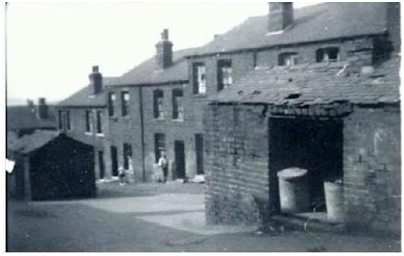
St George Church 'School Hall'
Church Street..The grounds where once stood the ‘School Church Hall’.The School Church Hall over the years was used for various activities,, Local functions, Schooling, Receptions, Village activity clubs, 'Drop in Centre, library, Jump Youth Club and many more....
After demolition (circa 1987/88) the land laid empty for many years, until 2011 which saw the land became a small housing development, ‘Church House Mews’..
St George Church 'School Hall'


1874 - 1988


Church House Mews Built 2011

Spencer’s Garage..Roebuck Hill
Spencer's Petrol Garage (Frank & Denise) (date) at the top of Roebuck Hill. Photo also shows the Spencer's second bungalow in the process of construction. After the closure of the garage 'circa early 70s' the premises became occupied for a short while by ‘Kirby Hoovers’, until the land was purchased by ‘Cryo Services’ who traded there for a number of years, until moving to new premises circa 2003
The land was eventually sold to housing developers, where the site now forms the ‘Roebuck Ridge’ Development, constructed 2005.
The Bungalow and the one in progress situated at the Side of the garage are still there, and still in ownership of the Spencer family.
Spencers Garage


Roebuck Ridge Built 2007


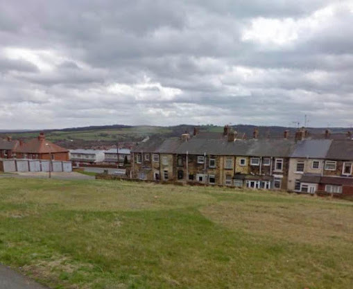
Turners’ field
Once Our centre piece and short-cut.
In the past the land has had various dwellings and ownership, probably the most well know landmark being the ‘halfway houses’ obviously a pointer but not sure of what!!...but I and like most of my friends always referred to it as ‘Turners’ field..
Turners bought the land from Mrs Garside circa 1971..The intentions of buying the land was to build a new Butchers in preparation.. Barnsley Council had earmarked the row of shops for demolition, as part of Jumps new development programme. However, these plans never materialised and Jumps longest established and renowned family butchers stayed in the same premises from the day of opening.. (1937 at the age of 28yrs old, Percy Turner Snr,)..
The land was left as an open green centre piece, with the later addition of 'the bench' which it self became a memorable feature of the village.
Eventually the land was sold in 2009 to make way for the new build that we see today..
Turners


Wentworth Mew Built 2013


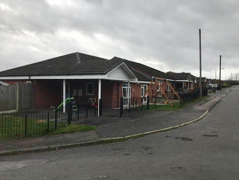
From Milton Road, Fitzwilliam Street, Inkerman Row, Milton Square.. circa 1850/60s - 1967/68..
To Joan’s Walk, Flats and Peet Walk 1972 – 2003..
Now The Children Centre, Ellin Close, Wentworth Road..
2006 – Present..
Milton Close.. 1988 - Present..
The ‘Turkey’ stood for over 100yrs,,
let’s hope this build last longer than the previous one..
Still unsure why Joan’s Walk & Peet Walk were demolished...


Wentworth Road, The Flats, Joan’s Walk
And Peet’s Walk circa mid 80s

Joan’s Walk and Peet’s Walk circa 2002/03 still standing afterThe demolition of the flats..
Demolition of the Flats 1981


The Present 2020


The Victorian Village School 1880 – 1981
From The 1800s Through To The Late 70s Before Demolition In 1981..
And to the present primary school...


Demolition of the school 1981


New Infant School (Three Classes) Builit 1965/66
Now forms part of the new school

The new primary school


Winters Day


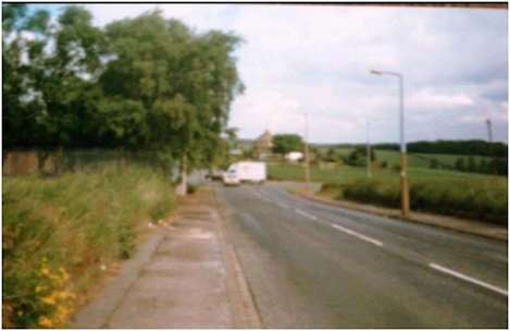
The Old Jump Crossroads to Present 2020
Showing our past of the old Jump Crossroads, to the new roundabout reconstruction that forms part of the 'Dearne Valley Parkway'..
How the defunct Jump road looks today, that formed the 'Four lane Ends' crossroads..

‘Four Lane Ends’ This photo taken from Roebuck Hill looking towards Wood Head Lane 1906, you can see ‘Springfield Cottage’ to the right of the photograph. These are workmen taking a break from working on the Development of Jump Crossroads..
Old Jump 'Four Lane Ends' Crossroads...


The defunct road that formed part of the Crossroads


Looking from Woodhead Lane, you can see the opposite road that formed the crossroads...
Pleased they didn't destroy the old road,,it's part of our history....
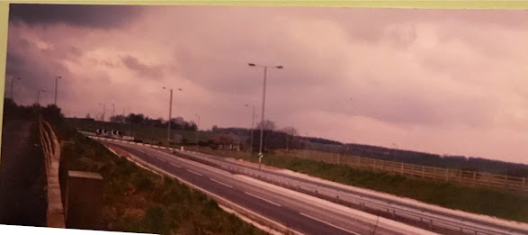
The New Roundabout that replaced the 'Jump Crossroads..
Now forms part of the 'Dearne Valley Parkway' A6195
1999 - Present


Driving towards the Jump roundabout 2007
The changing of Jump St George's Church over the decades


How the Church looked for decades after the removal of the tower

Under reconstruction.. Circa 1989/90
Entrance Improvements, Washroom/Toilet, Kitchen

The Church after completion and with the boundary wall height reduced.
(Viewed by many at the time, as an eyesore)


Transformation of Sunny Bank
Sunny Bank, probably the most secluded area of our village.
In past years was a short cut for the villages onto the Jump valley/rocks; and in the 50s & 60s, the sun bathing and training area for our well known bodybuilder, Mr Charles Jarrett...During the early part of the 70s the valley, that was once the home to Jump Pit in the mid 1800s became for a couple of years landfill. Whwn the competion of landfill came to an end the area was transformed into what we see today.. The road through Sunny Bank leading to the Rocks/Valley came to an end in the late 70s due to movemwnt to the enbankmenk, the bottom area of Sunny Bank was fenced for public safety..Though the entrance to the valley was redirected, Sunny Bank road is still open to general public and to access the rear of Church Street. The road for many years as been classified as 'Unadopted' by BMBC..
The origins of the name ‘Sunny Bank’ up to date, remains a mystery. One can only assume, with the area once surrounded by open fields and large valley, I’d imagine during those hot summer months the embankments bathed in hours of beautiful sunshine, thus the name Sunny Bank. That’s my own personnel view..
circa 1877
Past records show that Sunny Bank had approx 12 dwellings. There are two other builds, one in the corner of the far right, and one on the edge of the ‘Rocks’ overlooking the valley, not sure if these are dwellings or outer buildings. The lay out consisted of: Two standalone adjoining cottages, a gap/pathway of approx 2mtrs, then a row of six terraced dwelling, behind those a further row of four. These lay vertical creating an L shape. Entry to these were by the foot path beside the two adjoined cottages.
The majority of the dwellings were demolished many, many years ago, only two remained, the ‘standalone’ adjoined cottages, known as ‘RoundHill Field’. Some documents refer to them as numbers 1 and 2, others as number 1 and 3.
The last two residents of these cottages were: No1 Mr Enoch & Mrs Gertrude Ellis (Ronnie Snr mother) Lycett. No2 Mr & Mrs Oxspring. Previous to the Oxsprings were, Mr ‘Harry’ & Mrs ‘Dora Turner’ (sister to Percy Turner Snr) Garwood.
The houses became unoccupied around 1967/68..
The transformation of Sunny Bank, started in the early 60s when brothers Bob and Ernest Ackroyd purchased the surrounding open land, from landowner Mr Hague By the mid 60s both brothers had built two beautiful spacious family bungalows and outer buildings; Bob & Celia ‘Roundhill View’ and Ernest & Margaret ‘Fair View’. This continued when in 1969/70 Roy Powell and wife Madge purchased both 'Roundhill Field' cottages and transformed them both into one large family home.
Sunny Bank, remained the same until the latter end of the 80s when Bob Ackroyd, with help from his brother Jim, built a bungalow adjacent to ‘Roundhill Field’ where many years before stood the six cottages..In 1989 Bob and family moved into the new build, selling their previous home ‘Roundhill View’ to well known butcher, Barry Turner and family. Both Barry and Bob still reside there..2020..
Sadly, of all the people that transformed Sunny Bank from the 60s, for what we see today, only Bob Ackroyd is still with us....
No 1 & 2 ‘Roundhill Field’ Cottages.. Photo circa 1953/54


1967 - Present


‘Roundhill Field' Cottages’


Number 1 & 2 Present 2020
'Roundhill View' Bungalow


'Fair View' Bungalow.,


Bob & (Celia) Ackroyd Bungalow.

1989 - Present
That much used short cut through Sunny Bank to the ‘Rocks’ came to an end in the early part of the 70s when the open field beyond the ‘Rocks’ which was once Jump Pit, became landfill. The area was closed and fenced for safety reasons..
Coach & Horses Inn ‘Middle House’ 1865 – 2014
The first Public House to close in our village for nearly 100yrs the 'Red Lion' circa 1916/17


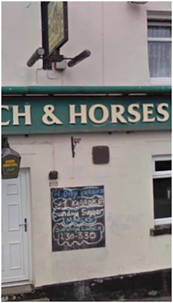


locally known as the 'Middle House'


In progress of new development of apartments

Compete 'Coachman's Court' Appartments 2018

Arundel View
Been part of our village for over 150years.Maybe in its very early the land occupied a small farming settlement with dwelling, but for the most recent years it laid as open land.This changed in the early 60s when the land became earmarked for development of council houses.In 1965 saw the construction builds of semi detached houses, ‘four in a block’ flats and brick built garages..This is how the Avenue remained until 2005 when the Avenue flats were demolition after finding that ‘Red Ash’ had been used in the foundation..This made way for new builds of link semi detached bungalows.
Arundel View Flats

1965 - 2015
Arundel View Flats.. Demolished in 2005, due to the foundations having evidence of ‘Red Ash’

Arundel View Semi Detached Houses 1965 - Present
After Demolition of the flats


New Build Link Bungalows


Comments